|
Mining Claims are made
by discovering a locatable mineral on public lands, staking
a claim and filing a notice with the local county recorder.
If done in accordance with federal and state regulations,
practically anyone may stake a claim on public lands in the
United States.
Identifying where the
Active Mining Claims lie is one of the greatest challenges
facing the prospector. A FootPrints Map puts you miles ahead
in researching the claims status of any area on the map.
We obtain copies of Claimants filings from the
County Recorder for all claims listed as Active by the BLM.
We then map each claim to the ACTUAL boundaries as defined
in the filing.
You will not find this map layer elsewhere.
The BLM records claims only to the Quarter Section and can
be misleading in its presentation.
Consider the Following Example:
 |
|
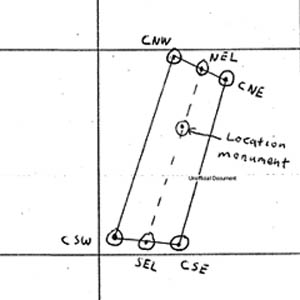
The
image on the left was obtained from the Location Notice
filed with the County Recorder for the Claim named;
"GORY GEORGE I"
This is a portion of the Claimant's map locating
the boundaries of his claim. |
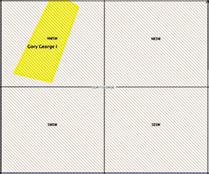 |
This image shows
the claim mapped to its ACTUAL boundaries by FootPrints
in Yellow.
The BLM maps the claim with slanted lines and
shows the "GORY GEORGE I" claim covering the
entire Quarter Section.
This is misleading.
Most of the Quarter Section is actually unclaimed.
|
How many times have you heard that an area you
want to prospect is "All Claimed Up"?
A FootPrints Map
will help you decide for yourself.
|