Custom Claims Map Layers
 

FootPrints gathers all the complicated information about Active Mining Claims in the area and presents it to you in an easy to read format.

Each FootPrint maps all Mining Claims, lode and placer that are listed as Active Claims with the BLM at the date of release.

Using the Information Mode, clicking on any area of the map will display a listing of mining claims.This list contains information on each claim that is obtained from the BLM LR2000 database. Known Prospecting Club claims are identified here as well.

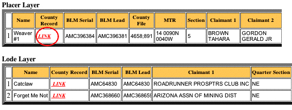
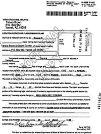
Clicking on the "Link" field opens a new window that displays a copy of the Actual Claim Filing from the County Recorders Office.

You can read the specifics about who owns the claim, when it was filed and where it lies.

This is not an internet link to the County Recorder, its is a digital copy of the filing.

FootPrints has the most comprehensive Claims Maps available to the Prospector.