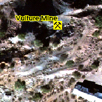
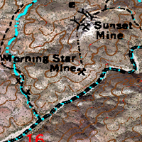
More Standard Map Layers


Geology

Each FootPrint has a Geology Layer showing you the basic geologic make-up of the area.

When we have access to geologic reports for the area we will provide detailed custom geologic layers.


Mines

Each FootPrint also has a Historical Mines Layer. This mines information is obtained from a variety of sources, the MRDS, State Mining Bureaus and others.

We provide a database of information which can be quite extensive depending on the sources available.

We review all data for accuracy of mine location and duplication of data. We do our best to take the mystery out of locating old mines.


Transparent Topo Map

This Map Layer allows you to take the USGS Topographic Map with all of its notes and symbols and display it directly over the Aerial Imagery or the Shaded Elevation Base Map.

This provides a detailed, but familiar look at the area you want to prospect.