| |
Prospectors need specific
information regarding land ownership of the area they want
to prospect. In order to file a claim or obtain detailed land
ownership information, it is important to be able to identify
your Township, Range and Section.
FootPrints will show you
who owns the land and if Federal, what agency manages the
land. If lands are withdrawn from Mineral Entry, FootPrints
maps the boundaries of the withdrawn areas.
FoorPrints maps the Legal
Land Description displaying the Meridian, Township, Range
and Section (MTRS) references for the area.
 |
|
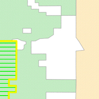
Ownership
A color coded ownership layer shows you who
owns the land. Private, BLM, Nat'l Forest and other
lands are clearly differentiated.
FootPrints will also map any lands withdrawn
from Mineral Entry.
|
 |
|
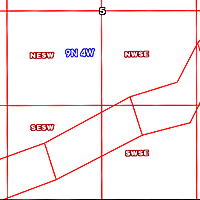
MTRS
The MTRS Layers allow you to know the Legal
Land Description of an area including the Federal survey
numbers.
Each FootPrint provides three layers to display
the Legal Land Description;
MTR - Meridian, Township and Range
Section
Quarter Sections - Quarter Sections and Alliquots. |
 |
|
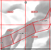
Patents
Patented land is Private land.
Not all Patented lands were given mineral rights
along with the surface rights. Some remain with the
Federal Government.
FootPrints provides a digital copy of each
original Patent issued for all patented land on the
map.
|
|
| |
|
|
|